
-
-
-
-
-
-
-
-
-
-
-
-
North Carolina
-
-
-
-
-
-
-
-
-
-
-
-
-
-
-
-
-
| Map of the Bartram Trail |
 |
|
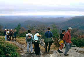
| Members of the North Carolina Bartram Trail Society at Scaly Mountain, Macon County. |
Exploration of the Cherokee Country, 1775–85
At the site of old Fort Prince George in South Carolina, Bartram had hoped to obtain an Indian guide for the remainder of his journey through Cherokee country. On the opposite side of the river was the old site of Keowee, formerly chief town of the lower Cherokees, but at the time of Bartram’s trip, uninhabited. At the site of the fort were several dwellings inhabited by white people, the old fort itself, serving as a trading house.
After spending two or three days here without having succeeded in obtaining a guide, Bartram determined to continue his journey alone. He left this place about May 19, 1775,(86) traveling on horseback (as he had throughout most of his trip) through northern parts of present-day South Carolina and Georgia.(87) Toward evening of this first night out of old Fort Prince George, Bartram sighted an unoccupied Indian hunting cabin where he spent the night, grateful for the shelter after having been caught in a torrential thunder storm during the afternoon. The next day, he reached the waters of the Little Tennessee River. He followed down it “pursuing my serpentine path, through and over the meadows and green fields and crossing the river.”(88) After traveling some miles down the river, he came to “a very beautiful creek, which flowed into the river just before me; but now behold, high upon the side of a distant mountain overlooking the vale, the fountain of this brisk flowing creek; the unparalleled water fall appears as a vast edifice with crystal front, or a field of ice lying on the bosom of the hill.” This was Estatoah Falls.(89) Bartram was nearing North Carolina. Here, Bartram was forced to ford the river “which was greatly swollen by the floods of rain that fell the day before.”(90) The river’s volume was such that he “was obliged to swim two or three yards at the deepest channel of it, and landed safely on the banks of a fine meadow, which lay on the opposite shore, where I immediately alighted and spread abroad on the turf my linen, books and specimens of plants, &c. to dry, turned out my steed to graze and then advanced into the strawberry plains to regale on the fragrant, delicious fruit.”(9l) It is at about this point that he entered present-day North Carolina.
Farther down the trail, he observed that the surface of the land was level but rough, covered with stones of various sizes. On each side of the trail he saw “vast heaps of these stones, Indian graves, undoubtedly.”(92) In a footnote he identified this as a place where “was fought a bloody and decisive battle between these Indians and the Carolinians, under the conduct of General Middleton.”(93) This was the second battle of Echoe which took place just below the present-day community of Otto, North Carolina on June 10, 1761. The Cherokees here attacked a force of British soldiers and provincials under the command of Lt. Col. James Grant. Another group of provincials, under the command of Col. Middleton, played a key role in repulsing the attack. The Cherokees lost a score or more killed and a great many wounded. Grant’s army lost 10 killed and 53 wounded.(94)
 |
Toward evening, Bartram came to a trading house operated by a white man and his Cherokee wife. Here, he was hospitably received and spent the night. The next morning, about May 21, 1775, after enjoying a substantial breakfast provided by his host, Bartram resumed his journey. About four miles by Bartram’s reckoning, brought him to the town of Echoe “consisting of many good houses, well inhabited; I passed through and continued three miles farther to Nucasse, and three miles more brought me to Whatoga.”(95) Echoe was near the junction of Cartoogechaye Creek with the Little Tennessee. Nucasse was within the present-day city limits of Franklin, North Carolina. A large mound there has been fenced off and preserved. Whatoga was, as Bartram says, three miles down the Little Tennessee from Nucasse and on the same (west) side of the river.(96)
The road which Bartram was following led into the town of Whatoga, “up to the council house, which was a very large dome or rotunda, situated on the top of an ancient artificial mount,”(97) and here the road ended. Bartram was at a loss as to which way to proceed. While deciding what to do next, he observed an Indian man beckoning to him from the door of his house several hundred yards distant. This man, the head of the village, received Bartram hospitably, had his horse cared for, and provided “a refreshing repast, consisting of sodden venison, hot corn cakes &c. with a pleasant cooling liquor made of homony well boiled, mixed afterwards with milk.”(98) After the meal, the chief brought out tobacco and a special pipe with a long (four foot) stem, “sheathed in a beautiful speckled snake skin and adorned with feathers and strings of wampum.”(99) When it came time for Bartram to continue his trip, his host gave him directions to Cowee and accompanied him about two miles on the way. The town was not far (about seven miles from Whatoga) and Bartram soon arrived there. This was about May 21, 1775. Of Cowee he wrote: “This settlement is esteemed the capital town; it is situated on the bases of the hills on both sides of the river, near to its bank, and here terminates the great vale of Cowe, exhibiting one of the most charming natural mountainous landscapes perhaps anywhere to be seen.”(l00) The town of about 100 dwellings was situated at the mouth of the Cowee Creek (on the site of today’s West’s Mill, North Carolina).
On the return trip, Bartram again passed through Cowee, and at that time described the council house. “The council or town-house is a large rotunda, capable of accommodating several hundred people; it stands on the top of an ancient artificial mount of earth, of about twenty feet perpendicular, and the rotunda on the top of it being above thirty feet more, gives the whole fabric an elevation of about sixty feet from the common surface of the ground. But it may be proper to observe, that this mount on which the rotunda stands, is of a much ancienter date than the building, and perhaps raised for another purpose.”(l0l) There is today a rise on the west side of the river which locally is known as the mound on which was situated the council house. Not far distant, in rock outcroppings, are grinding holes, or hominy holes, where the indians ground their corn.
Upon his arrival at Cowee, Bartram presented himself to certain individuals for whom he bore letters of recommendation. He took up residence with a Mr. Galahan, the chief trader of the village, and a man held in esteem by the Indians. On the following day, about May 22, 1775, Bartram crossed to the east side of the river by canoe, to visit a trader who lived there.(l02) “After dinner, on his mentioning some curious scenes amongst the hills, some miles distance from the river we agreed to spend the afternoon in observations on the mountains.”(l03) This excursion took them up Cowee, Beasley and Huckleberry Creeks to Leatherman Gap atop the Cowee range. The first two miles took them through fields of corn and beans, well cultivated and clean of weeds. Leaving the fields, they began to ascend more steeply, the air “cool and animating” as they gained higher altitude. Upon reaching the summit of the ridge, “we enjoyed a fine prospect, indeed; the enchanting Vale of Keowee,(l04) perhaps as celebrated for fertility, fruitfulness and beautiful prospects as the Fields of Pharsalia or the Vale of Tempe; the town, the elevated peaks of the Jore mountains, a very distant prospect of the Jore village in a beautiful lawn...; the bold promontories of the Jore mountain stepping into the Tanase river, whilst his foaming waters rushed between them.”(l05)
Descending the other side of the mountain, they came on the waters of Alarka Creek. Here, in a verdant meadow, the trader had many fine horses pastured. each year, as they matured, he sent a group to Charleston for sale. Continuing a bit further, the men encountered a group of Cherokee women gathering strawberries. The event produced one of Bartram’s most vivid descriptions. They recrossed the Cowee range west of their earlier crossing(l06) and arrived back in Cowee by evening.
At Cowee, Bartram had hoped to obtain a guide to accompany him to the Overhaul towns, but again he met with disappointment just as he had at Fort Prince George. After waiting two days, he determined to continue alone. Because there had been trouble between the Overhill Indians and Virginia settlers, Bartram was advised by the Cowee traders not to proceed further alone, but about the twenty-fourth of May he set out anyway. He was accompanied for about fifteen miles by the trader, Galahan, with whom he had lodged in Cowee. Their course took them back up the Little Tennessee River for a few miles, then westward along the Iotla Creek which Bartram calls the Jore, and Iotla Branch. They passed through the Jore Village, situated on the watershed of Iotla Creek.(107) At Parrish Gap another branch of the trail form the overhill towns to Cowee came in on the right, and here Galahan took leave of Bartram, taking this trail back to Cowee.(108)
Alone, Bartram proceeded down Parrish Creek to Burningtown Creek, which he forded with difficulty. His trail then followed Burningtown Creek, upstream. Soon Bartram began the ascent toward Burningtown Gap. While pausing for lunch beside the stream, Bartram was startled to see a husky young Indian bearing a rifle and accompanied by two dogs, suddenly appear within a few yards of him, coming from around the point of the ridge. The Indian, also, appeared startled, but soon regained his composure. He advanced, shook Bartram’s hand in a friendly manner, and inquired from whence he came and where he was going. Their conversation was friendly but brief, being in the Cherokee language of which Bartram had only a limited knowledge. Bartram presented the young man with some choice tobacco; they shook hands “and parted in friendship, he descended the hills, singing as he went.”(109)
Relieved by the friendly parting and revived by his lunch break, Bartram continued on up the trail to Burningtown Gap.(110) Here, he left the trail briefly to climb the highest of the nearby peaks “from whence I beheld with rapture and astonishment, a sublimely awful scene of power and magnificence, a world of mountains piled upon mountains. Having contemplated this amazing prospect of grandeur, I descended the pinnacles, and again falling into the trading path, continued gently descending through a grassy plain.”(111)
 |
|
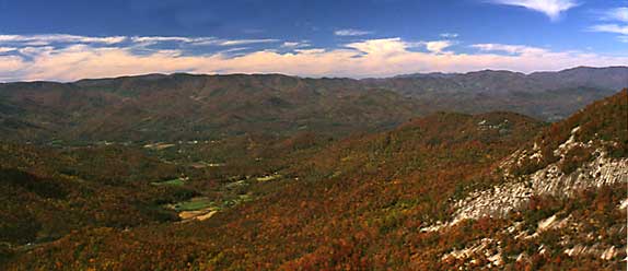
| A view of the Nantahala Mountains from Wayah Bald |
From Burningtown Gap the trail led down the west side of the Nantahala range to the vicinity of present day Kyle. This could have been along the route followed by the present road down Ben Creek or along Split Whiteoak Ridge. The “considerable rapid brook” he descended was probably Whiteoak Creek. From Whiteoak Creek the trail would have been up Bateman Branch, through Bateman Gap, across the head of Long Branch and through Otter Gap to Otter Creek. Thus he proceeded “several miles over ridges and grassy vales, watered with delightful rivulets.”112 Somewhere in this area he spent the night of May 24th.
The next day, after “proceeding on eight or ten miles, generally through spacious high forests and flowery lawns”(113) he came to a large creek or riverundefinedno doubt, the Nantahala. His route to this point would have been across the ridge from Otter Creek by way of present-day Briertown to Partridge Creek. Then up the left fork of Partridge Creek and across a gap to the head of Queens Creek. From there he probably followed the route of the present Winding Stairs Road to the Nantahala River near present- day Beechertown. A highway marker not far from here commemorates Bartram’s meeting with the great Cherokee Chief, Attakullakulla.
Bartram records that, soon after crossing the river, he saw a company of Indians, mounted on horseback, coming down the mountain in his direction. As they came nearer, he saw a chief at their head whom he correctly assumed to be Attakullakulla.(114) Their meeting was friendly. Attakullakulla made inquiry about John Stuart, Superintendent of Indian Affairs with headquarters in Charleston, whose life had been saved by Attakullakulla at the time of the fall of Fort Loudon and whom Attakullakulla was then on his way to see.
 |
|
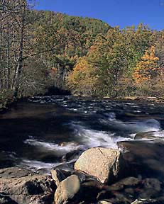
| Nantahala River |
The next day, having decided continuing on to the overhill towns at that time was too hazardous, he turned back toward Cowee, which he reached in the evening of May 27th.(115)
The next day, May 28, the trader Galahan presented Bartram to the chief of Cowee who had been absent when Bartram was in Cowee on his way through. The rest of this day was spent in various activities, including observations of the town and caring for the specimens he had collected. That evening, Bartram accompanied some of the traders to the rotunda where a grand festival with music and dancing was held. He gives an interesting account of this event.(116)
The next morning, May 29, Bartram set out on the return trip and in two days (on the evening of May 30) arrived back at Keowee.
Return to Philadelphia, 1776
On his return trip to Philadelphia Bartram passed through North Carolina once again. He entered the state north of Charleston, South Carolina, near Little River on what is now known as the Old Georgetown Road. Traveling northeast, he passed through present Calabash, Shallotte, and Supply. From the last point, he may have taken a road to present Southport and then turned northward along the west side of Cape Fear River to Brunswick; or he may have taken a more direct road through present Bolivia. In either case, he reports spending the evening at “Old town near Brunswick.”(117)
The next day Bartram proceeded up the west side of the Cape Fear River, “rested two or three days at the seat of F. Lucas, Esq.” in southern Bladen County, and then continued on to his uncle’s plantation, “Ashwood” (on the east bank of the river about five miles northeast of Council, Bladen County).
Bartram had spent more than seven years living at his uncle’s property “on the high banks of the river”(118) and knew it well. His vivid description of the site in Part Three of the Travels reflects his fondness for Ashwood. It is regrettable that the house no longer stands today.
Leaving his late uncle’s plantation for the last time, Bartram “continued up the west side of the river”(119) passing through present-day Elizabethtown and Tarheel, but between Dublin and the river. From Cambellton (Fayetteville) the route probably went north-northwest through or near present Manchester, Spout Springs, Jonesboro, Sanford and Pittsboro, across Cane Creek in extreme southern Alamance County. From the Quakers Meeting House above the creek, Bartram traveled northeast (perhaps along the old Woody’s Ferry Road) to Hillsboro, Orange County, and Oxford, Granville County. He left the state by crossing the Roanoke River into Virginia somewhere between Island and Nutbush Creeks. It was, in his own words, “the hoary frigid season”(120) or December, 1776..
Footnotes
84. See: Francis Harper, "William Bartram and the American Revolution," Proceedings of the American Philosophical Society, Vol. 97, No. 5, October 1953; and Naturalist’s Edition, op. cit., p. 416.
85. For this account of Bartram’s 1775 trip into western North Carolina, the Bartram Trail Conference is indebted to Rowell D. Bosse and Charles F. Moore for their Technical Study, "The Probable Route of William Bartram’s Travels in North Carolina," 1978.
86. In his journal, Bartram gives the year of this journey as 1776. Apparently it actually was made in 1775. For a discussion of this, see Harper, Naturalist's Edition, op. cit., p. 380. As to the exact day of the month that Bartram arrived at or departed from a particular point, authorities are frequently in disagreement. This is because Bartram does not always give the exact number of days spent at a place nor the date of departure.
87. Bartram’s route, as presented here, would have been along the lower Cherokee path to the overhill towns. Mr. Harry R. Wright, Mayor of Highlands, North Carolina (to whom the Bartram Trail Conference is indebted for assistance), is of the opinion that at this time Bartram was following the upper or northern Cherokee path to the overhill towns. This path would have taken him across the Chattooga River at Burrell’s Ford and up Hale Ridge, entering North Carolina near Commissioner's Rock. (See map by Margaret Mills Seaborn, 1974.) His route then would have been down Middle Creek to the Little Tennessee River. In this case, it would have been one of the falls on this creek which so impressed Bartram, rather than Estatoah Falls. This view seems to gain some support from Wilburn, who says that Bartram climbed up and over the southwest corner of the Highlands Plateau, though he thinks that Bartram’s course was down Mud Creek. Harper favors the lower or southern path, as presented here.
88. Bartram’s Travels, p. 346, Harper, p. 219.
89. Ibid., p. 347, Harper, p. 220.
90. Ibid. Bartram does not say so, but indications are that the crossing was from east to west. Harper shares this opinion.
91. Bartram’s Travels, op. cit., p. 347, Harper, p. 220.
92. Ibid., p. 348, Harper, p. 220.
93. Ibid.
94. David H. Corkran, "The Asheville Citizen-Times," November 22, 1953.
95. Bartram’s Travels, op. cit., p. 350, Harper, p. 221.
96. Bartram does not indicate which side of the river Whatoga was on, but the preponderance of evidence seems to place it on the west side. Some early maps do show it on the east side. Harper speculates that, like Cowee, it may have occupied both banks. Nucasse was on the west side of the river, and if it had been necessary for Bartram to cross, it seems likely that he would have so indicated.
97. Bartram’s Travels, op. cit., p. 350, Harper, p. 221.
98. Ibid., p. 351, Harper, p. 222.
99. Ibid.
100. Ibid., pp. 352–353, Harper, p. 223.
101. Ibid., p. 367, Harper, p. 232.
102. There is nothing in the Travels to show whether this crossing was from west to east or in the other direction. Harper evidently thinks that the crossing was from east to west, as he indicates a course for the afternoon excursion which took Bartram and the trader up Rose Creek, across Burningtown Creek four or five miles above its mouth, the horse stamp near the mouth of Parrish Creek, and the return by way of the Parrish community. Wilburn favors a route almost diametrically opposite.
103. Bartram’s Travels, op. cit., p. 354, Harper, p. 224.
104. No doubt Bartram meant Cowee. Harper, pp. 224–225.
105. Bartram’s Travels, op. cit., pp. 354–355.
106. Ibid., pp. 356-358, Harper, pp. 225–226.
107. Both Harper and Wilburn think that Bartram went up Iotla Creek and through Iotla Gap. The Jore village was about four miles to the northeast of Nequasse and a mile or two from Wattoga (Whatoga). (See: David H. Corkran, ”Asheville Citizen-Times,” November 29,1953; and John H. Goff, "The Georgia Mineral Newsletter," date N/A). If this is true, Harper has placed this village entirely too far west.
108. Wilburn thinks that it was at Iotla Gap that Galahan took the trail back to Cowee. The route to Parrish Gap seems to agree more closely with Bartram's description of the terrain. Harper thinks that it was in the Wayah Creek valley that Bartram and Galahan parted. This does not seem a logical place for a trail from Cowee to come in on the right, according to Bosse and Moore.
109. Bartram’s Travels, p. 362, Harper, p. 229.
110. Harper thinks that Bartram crossed through Wayah Gap. The Burningtown Gap route is suggested by Messrs. Bosse and Moore based on their own field research; see Harper, Naturalist’s Edition, op. cit.
111. Bartram’s Travels, op. cit., p. 362, Harper, p. 229.
112. Ibid., p. 364, Harper, p. 230.
113. Ibid.
114. Harper thinks that Bartram crossed the Nantahala River in the vicinity of Aquone and that it was between there and Old Road Gap that he met Chief Atakullakulla; see Harper, Naturalist's Edition, op. cit.
115. It is Harper’s opinion that the point where Bartram turned back was in the Junaluska Creek valley not far from the present-day town of Andrews; Ibid.
116. See: Bartram’s Travels, op. cit., pp. 369–371, Harper, pp. 233–234.
117. Ibid., p. 473, Harper, p. 299 and pp. 419–421.
118. Ibid., p. 474, Harper, p. 300.
119. Ibid., p. 476, Harper, p. 302.
120. Ibid., p. 479, Harper, p. 303.